Lands End Coastal Trail: San Francisco's Wild Edge on Foot
What is the Lands End trail in San Francisco?
Lands End is a free, roughly 3-mile round-trip coastal trail at the city's northwestern tip, running along cliffs between the Sutro Baths ruins and the Legion of Honor, with Golden Gate Bridge views, shipwreck remnants and moderate elevation changes. It's open daily, dawn to dusk, with no ticket or reservation required.
A cliffside trail most visitors never find
Most first-time visitors to San Francisco budget a morning for the Golden Gate Bridge and an afternoon for Fisherman’s Wharf, and never make it to the city’s actual northwestern tip. That’s the gap Lands End fills: a genuinely wild-feeling coastal trail, inside city limits, with no entrance gate and no ticket, that delivers cliffside Pacific views, crumbling Victorian ruins, and a shipwreck-scarred shoreline in about two to three hours round trip.
Lands End sits at the far edge of the Richmond District, past Golden Gate Park and just north of the Legion of Honor museum. It’s managed by the National Park Service as part of the Golden Gate National Recreation Area, which is why — unlike most of San Francisco’s paid attractions — it costs nothing to walk. The trade-off is that it demands slightly more planning than a stroll down the Embarcadero: parking is limited, some sections have real drop-offs, and the weather at this exposed western point can differ sharply from what’s happening a mile inland.
This guide covers the main route, the ruins and lookouts worth detouring for, how to get there with or without a car, and the mistakes that turn an easy afternoon into a bad one.
What the trail actually looks like
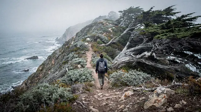
The core Lands End trail is an out-and-back path running roughly parallel to the coastline between the Sutro Baths ruins in the west and Eagle’s Point, overlooking China Beach, to the east — about 1.5 miles each way, 3 miles round trip. The surface is mostly packed dirt and gravel through wind-bent cypress and Monterey pine, cut into the hillside above the water, with the ocean visible for long stretches on the right heading east.
It’s rated moderate rather than easy for a specific reason: the trail itself has modest elevation change, but almost every worthwhile detour off it — down to the Sutro Baths ruins, out to Mile Rock Overlook, up the stairs to the USS San Francisco Memorial — adds staircases, loose gravel, or unguarded cliff edges. None of it requires technical hiking experience, but it isn’t stroller-friendly in its wilder middle section, and sturdy shoes matter more here than almost anywhere else in the city.
| Segment | Distance | Difficulty |
|---|---|---|
| Sutro Baths to Eagle’s Point (one way) | ~1.5 mi | Moderate |
| Full out-and-back | ~3 mi | Moderate |
| + Sutro Baths ruins loop | +0.3 mi | Easy, uneven footing |
| + Mile Rock Overlook spur | +0.5 mi round trip | Moderate, steps |
| + Labyrinth detour | +0.2 mi | Easy |
The landmarks worth stopping for
Sutro Baths ruins, right at the main trailhead, are the most-photographed spot on the whole route: the roofless concrete foundations of a vast Victorian public bathing complex that Adolph Sutro opened in 1896 and that burned down in 1966. What’s left is a maze of low walls and flooded pools, often with a heron or two, and a short unlit tunnel near the water side leading to a sea cave with waves crashing directly below — worth the short scramble, but not for anyone uneasy on wet rock.
Eagle’s Point, at the trail’s eastern end, gives one of the city’s best uncrowded views of the Golden Gate Bridge — useful on days when the bridge itself is wrapped in fog but the Marin headlands and the bay are clear, since the angle here often catches light the bridge deck doesn’t get.
Mile Rock Overlook, a short spur off the main trail partway along, looks out toward the small Mile Rock Lighthouse offshore and is one of the better whale-watching vantage points from land during migration season (roughly December-April and July-November, depending on species).
The Lands End Labyrinth, an unofficial rock spiral built and rebuilt by volunteers on a bluff above the cliffs, is a quirky, low-effort detour that photographs well against the ocean.
Shipwreck remnants are visible at very low tide near the Sutro Baths side — several vessels wrecked on this stretch of coast in the 19th and early 20th centuries, and their ribs occasionally surface in the sand.
For a broader sense of what else the western edge of the city offers beyond Lands End itself, the San Francisco neighborhoods guide covers how the Richmond District and the areas around Golden Gate Park connect to this part of town.
Trailheads and how to reach them
Lands End Lookout / Merrie Way parking lot (main trailhead): free, but small, and it fills by mid-morning on clear weekends. This is the western end, right next to the Sutro Baths ruins.
Legion of Honor parking (eastern end): a paid lot next to the museum, a reasonable option if it’s already full at Merrie Way, and a natural pairing if a museum visit is also on the day’s plan.
By Muni: several bus routes serve the Richmond District stops near both ends of the trail, making this one of the more realistic car-free hikes in the city — a meaningful advantage given how contested parking gets here on sunny afternoons, and consistent with the wider advice in the getting around San Francisco guide that a car is often a liability inside the city itself, not an asset.
Arriving before 10am, or after 3pm in summer when the afternoon crowd thins, is the most reliable way to get a spot without circling.
When to go
Because Lands End sits directly on the exposed Pacific coast, it experiences the city’s summer fog and wind more intensely than sheltered inland neighborhoods like the Mission. Mornings here can be cold and grey in July and August even when downtown is warm — the same microclimate pattern covered in the city’s best time to visit and weather by month guides. September and October, San Francisco’s real summer, tend to give the clearest views of the bridge and the coastline from here, with less wind than midsummer afternoons.
Late afternoon light is often the most dramatic for photos at Eagle’s Point and Mile Rock Overlook, but plan to be off the more exposed spur trails before dusk — there’s no lighting on the trail itself.
What to bring
A windbreaker or layered jacket year-round is non-negotiable — this stretch of coast is windier and cooler than almost anywhere else in the city, even on the same afternoon a T-shirt is comfortable downtown. Closed-toe shoes with real tread help on the gravel staircases and the wet rock near Sutro Baths. Water and a hat matter more here than the short distance suggests, since there’s minimal shade and no services along the trail itself — the nearest food and restrooms are at the Lands End Lookout visitor center near the main trailhead.
Combining Lands End with the rest of the day
Lands End pairs naturally with a Golden Gate Bridge visit, since the trail’s Eagle’s Point end faces almost directly at the bridge and headlands — see the Golden Gate Bridge visitor guide for the crossing itself, and the Lands End coastal trail’s westward view makes a good lower-key alternative to walking the span on a windy day.
Travelers building a broader coastal or hiking day around San Francisco sometimes prefer a guided option instead of self-navigating: a guided urban hiking tour that strings together several of the city’s best viewpoints covers ground like this with route-finding and commentary built in, which suits visitors who’d rather not study a trail map first. For those wanting to go further into Northern California’s coastal scenery on the same trip, a day tour combining the coastal redwoods with a Wine Country stop extends the same cliffs-and-forest theme well beyond city limits, and a redwoods and Sausalito day tour departing San Francisco works as a similar half-day alternative for travelers short on time.
Lands End also sits close enough to Golden Gate Park and the Haight-Ashbury neighborhood that an active day can chain all three together on foot or by bus, and travelers who’d rather see the western neighborhoods by bike than on foot might prefer the Golden Gate Bridge bike tour or a guided e-bike tour through the city’s western districts as a faster-paced variant of the same coastline.
Anyone assembling a full itinerary around this side of the city can check the self-guided walking tour of San Francisco or the downtown guided walking tour for how Lands End fits against the more central sights, and the San Francisco in one day itinerary or two-day highlights itinerary for where a morning here slots into a short visit.
Common mistakes at Lands End
- Underestimating the wind and fog. This is the single most exposed coastal point in the city; a jacket that felt unnecessary downtown becomes essential here, especially at Eagle’s Point and Mile Rock Overlook.
- Wandering off-trail toward the cliff edges for a photo. The soft, eroding bluffs above the ruins and near Mile Rock have caused real falls; stick to marked paths and railed overlooks.
- Arriving at midday on a clear Saturday expecting a parking spot. The Merrie Way lot is small and fills fast; go early, go late, or take Muni.
- Skipping water because “it’s only 3 miles.” There’s no water source on the trail itself, and the wind and sun exposure add up faster than the flat distance suggests.
- Treating the Sutro Baths tunnel as a casual stop in flip-flops. The rock is often wet and slick; it’s worth seeing but not worth a twisted ankle.
- Missing the tide. The shipwreck remnants and the fullest view of the ruins’ tide pools are only visible at low tide — check a tide chart rather than hoping.
Practical summary
| Detail | Info |
|---|---|
| Cost | Free (NPS land, no ticket required) |
| Distance | ~3 miles round trip (main route) |
| Difficulty | Moderate |
| Hours | Dawn to dusk, daily |
| Main trailhead | Merrie Way / Lands End Lookout, off El Camino Del Mar |
| Parking | Free but limited; arrive before 10am on weekends |
| Facilities | Restrooms and small visitor center at Lands End Lookout only |
| Best months | September-October for clearest views; year-round for the ruins |
Lands End trail: frequently asked questions
How long is the Lands End trail?
The main out-and-back segment between the Sutro Baths parking area and the Eagle’s Point overlook near the Legion of Honor runs about 3 miles (4.8 km) round trip. Adding the Sutro Baths ruins loop and a detour to Mile Rock Overlook brings a typical visit closer to 4-4.5 miles.
Is Lands End hard or easy?
It’s rated moderate. The main packed-dirt trail itself is fairly flat and well-graded, but staircases at Sutro Baths, the USS San Francisco Memorial, and a few spur paths to overlooks add real elevation change, loose gravel and drop-offs without guardrails in places.
Is Lands End trail free?
Yes. There’s no entrance fee, ticket, or reservation for the trail itself, since it’s managed by the National Park Service as part of the Golden Gate National Recreation Area. Only the adjacent Legion of Honor museum charges admission, and it’s optional.
Where do you park for Lands End?
The main free lot is at the Merrie Way / Lands End Lookout parking area off El Camino Del Mar, near the Sutro Baths ruins. It fills up on weekends and fair-weather afternoons, so arriving before 10am or using Muni is more reliable than counting on a space.
Can you see the Golden Gate Bridge from Lands End?
Yes — the Eagle’s Point overlook and the stretch of trail near Marshall’s Beach and Lincoln Park give some of the city’s least-crowded, most photogenic angles on the bridge, especially useful when the Marin side is clear but Karl the Fog is sitting over the span itself.
What are the Sutro Baths?
The roofless concrete foundations of a massive Victorian-era public swimming complex built in 1896 by Adolph Sutro, destroyed by fire in 1966. The ruins sit right at the trailhead, free to explore, with tide pools visible at low tide and a short tunnel leading to a cliffside sea-view alcove.
Is Lands End trail dog-friendly?
Yes, dogs on leash are permitted on the main Lands End trail as it’s part of the Golden Gate National Recreation Area, though rules vary slightly in adjoining sections — check posted signs at trailheads, since some spur paths and the Sutro Baths ruins area have tighter restrictions near cliff edges.
How do I get to Lands End without a car?
Muni bus routes serve the area near the Legion of Honor and the Sutro Baths side, making the trail one of the easiest wild-feeling coastal walks to reach car-free from downtown San Francisco — useful given how scarce and contested parking becomes on clear weekend afternoons.
Hiking in Muir Woods and Beyond
Verified deep-linked GetYourGuide tours. Book through these links and we earn a small commission at no cost to you.
GetYourGuide does not provide a product photo for this activity — the image shows the meeting point, photographed by us.